Other WA Projects
GSM’s portfolio of ‘greenfields’ pipeline projects include various tenement application packages in regional Western Australia with a multi-commodity focus reflecting increasing demand in the evolving commodity market.
Four Mile Well Project
This project is located approximately 9km north of the Laverton townsite in the Eastern Goldfields of Western Australia and consists of three granted exploration licenses for a total of 260km2.
The Laverton region is a well-endowed, world class mining jurisdiction, with a number of major gold and nickel deposits within close proximity to the Four Mile Well project area. Two significant nickel sulphide deposits (Windarra and Mt Windarra) are located to the west of the project area and the 1.3Moz Lancefield gold deposit is located less than 1km to the south of the project.
GSM has completed a detailed review to check the validity of historic geochemistry datasets within the project area. This study highlighted a previously unrecognised anomalous response in the historic data revealing an encouraging arsenic-bismuth-low level gold anomaly in the northern half of the project area.
GSM’s drill testing of these anomalies using initial reconnaissance air-core drilling programs have recorded encouraging low level gold anomalism including 4 metres @ 114 ppb from 40 metres and 4 metres @ 224ppb Au from 16 metres.
Caprice Murchison JV
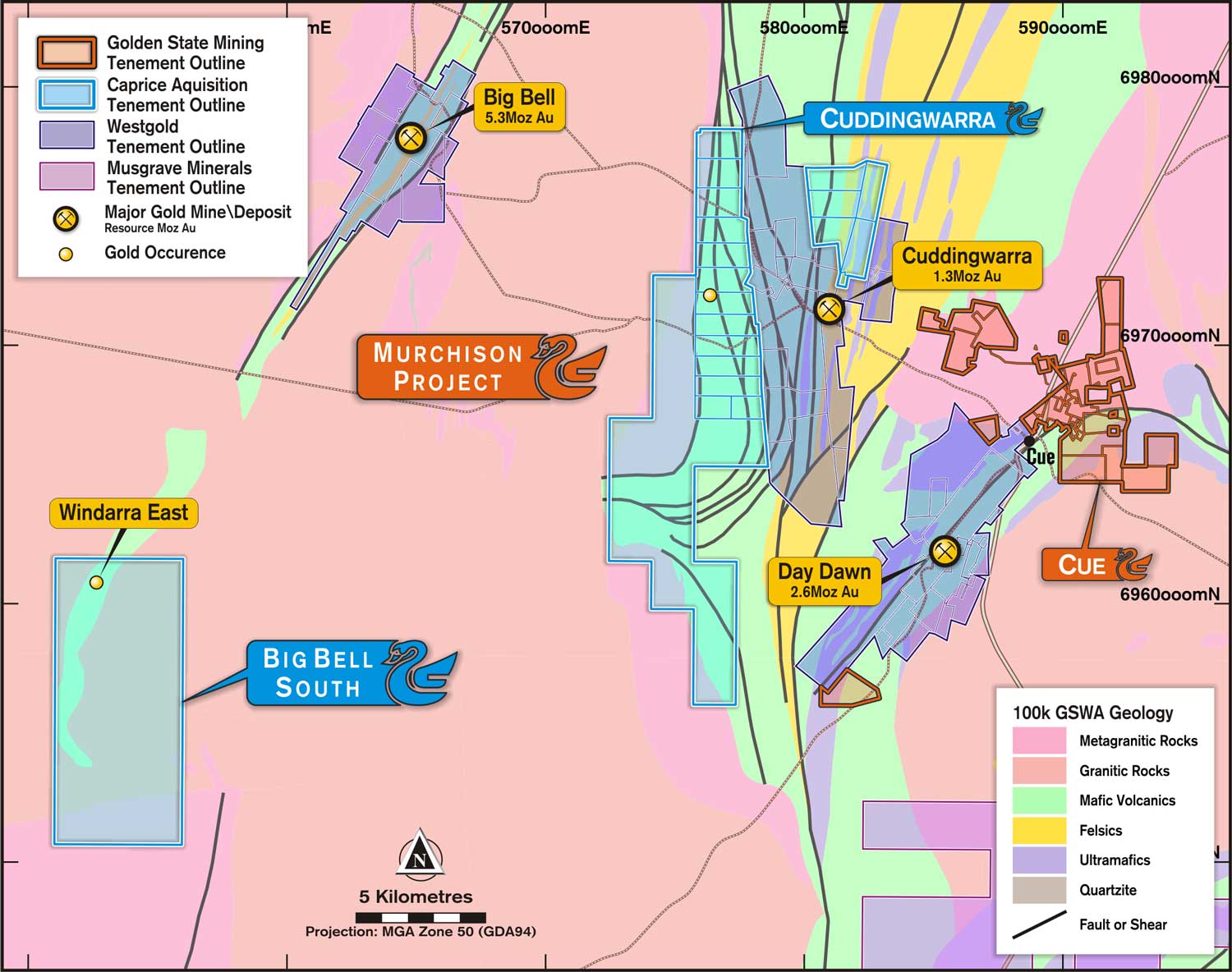
The Murchison project is a Joint Venture with Caprice Resources Limited (ASX:CRS) completed in July 2021 with Golden State Mining retaining a 20% share in the tenure which includes the Cuddingwarra and Big Bell South projects.
The Cuddingwarra project is located 540km north-east of Perth and 10km west of the town of Cue in Western Australia. The project resides in the Murchison Greenstone Domain, within the Youanmi Terrane of the Archaean Yilgarn Craton. The project is highly prospective for Archaean orogenic gold mineralisation. The project includes two separate tenement packages that straddle the north-south striking Cuddingwarra Shear Zone (CSZ).
The geology is dominated by a north-south striking sequence of basalt, high-Mg basalt, andesite and ultramafic units. The sequence is variable intruded by felsic to mafic dykes and sills and is folded to the south-west with a large-scale south-east plunging anticline. Second order shears from the CSZ and smaller scale linking structures have disrupted and deformed the greenstone sequence and are broadly associated with gold mineralisation.
Stratigraphy in the south-west is partly obscured by transported sediments. The Cuddingwarra West tenements are bordered by large granitic intrusions.
The Big Bell South project is located 520km north-north-east of Perth and 35km west of the town of Cue in Western Australia. The project resides in the Murchison Greenstone Domain, within the Youanmi Terrane of the Archaean Yilgarn Craton. The project is highly prospective for Archaean orogenic gold mineralisation.
The project includes a single exploration license (E21/193) over what is interpreted to be the southern extension of the Big Bell stratigraphy and fault. The tenement is located approximately 20km south of West Gold Big Bell gold deposit.
While the geology of the Big Bell deposit and stratigraphy is well studied and documented, the southern extension of the amphibolite facies greenstone sequence is poorly exposed with shallow alluvial cover over much of the tenement. Airborne magnetics suggests the southern extension of the Big Bell stratigraphy that runs through E21/193 is 0.5km to 1.0km wide.
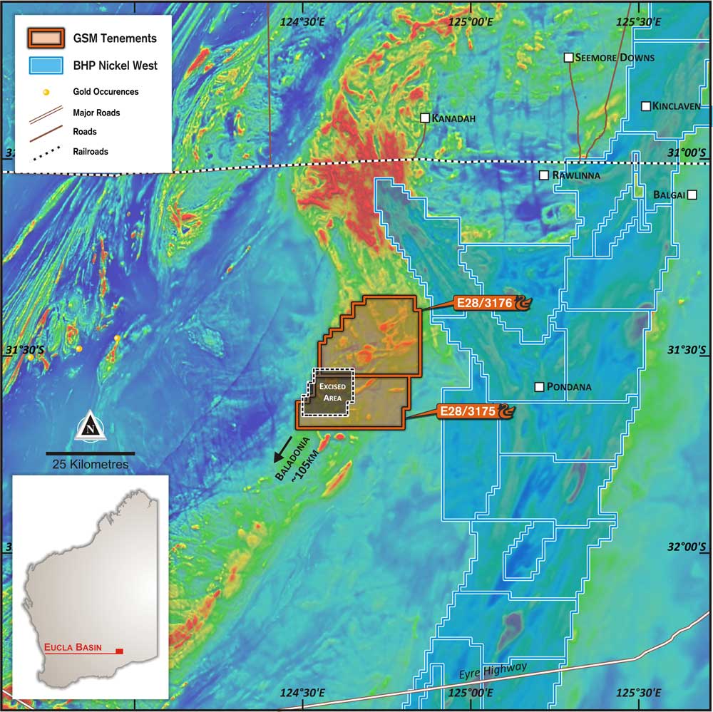
Eucla Basin (E28/3175 & E28/3176) – Copper- Au & Nickel
GSM has secured two exploration licence applications for a total of 974km2 approximately 100kms north-east of Balladonia and 300 km east of Kalgoorlie. The tenements host Mesozoic sediments and Tertiary limestones of the Eucla Basin which unconformably overlie deformed and poorly understood Proterozoic-age metamorphic basement rocks of the eastern Albany-Fraser Province (similar age rocks to Nova-Bollinger nickel-copper deposit and Tropicana gold deposit).
Buried magnetic and gravity anomalies and structures (up to 10 km long) have been previously identified (Teck Australia) and may represent a structurally deformed layered mafic-ultramafic intrusive at depth. The cover sequence is estimated by previous explorers to be 250-300 m depth. These anomalies represent intriguing base and precious metal targets and are yet to be drill tested.
Exploration work is underway and includes historic exploration compilation and assessment, geophysical modelling and interpretation, field reconnaissance and drill targeting.
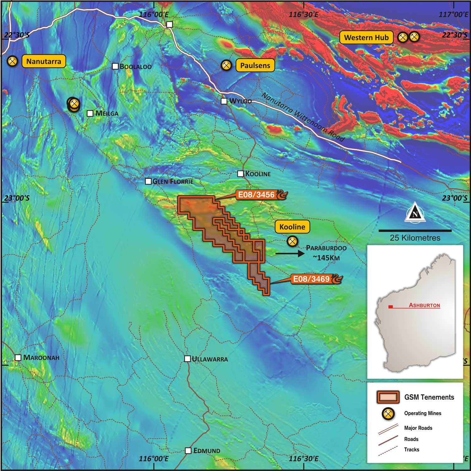
Ashburton (E08/3456 & E08/3469) – Lead-Silver & Gold
GSM has two exploration licence applications for a total of 302km2 approximately 12kms southwest of the Kooline airstrip, 135kms west of Paraburdoo. The tenements are considered prospective for VHMS style mineralisation in sediments proximal to basin bounding faults.
GSM plans to evaluate previous explorers’ exploration work affecting the project area and conduct preliminary reconnaissance and surface sampling programs.


